 Gebärdensprache
 Leichte Sprache

")
Nominee 2012
Radaraugen im All
 Dr.-Ing. Gerhard Krieger, Prof. Dr.-Ing. habil. Alberto Moreira, Dr.-Ing. Manfred Zink")
(f.l.t.r.) Dr.-Ing. Gerhard Krieger, Prof. Dr.-Ing. habil. Alberto Moreira, Dr.-Ing. Manfred Zink

Prof. Dr.-Ing. habil. Alberto Moreira, Dr.-Ing. Gerhard Krieger, and Dr.-Ing. Manfred Zink know the answer: they have developed a satellite duo with sharp radar eyes that sets their sights on the Earth from outer space – and is capable of mapping every corner of the planet in detail and in 3-D. To do so, radar sensors scan the Earth’s surface with microwaves. This provides a clear image of cities, forests, mountains and oceans even at night or through cloud cover. Alberto Moreira is the head of the DLR Microwave and Radar Institute and Radar where Gerhard Krieger and Manfred Zink work as department heads.
")
The list of applications in which geo-information is playing an ever more important role is long: for example, data can be used for traffic flow monitoring. Geo-information plays a role in ferreting out illegal clearing of trees in the rain forest or to check whether farmers are keeping to guidelines set for planting. Using geo-information, planners locate the optimum sites for offshore windparks, climatologists understand changes in glaciers and ocean currents due to climate change, relief missions are supplied with up-to-date information on crisis situations, even fissures or shifting on the slopes of volcanoes can be detected – as an early warning of an imminent eruption of the fire-spewing mountain.

more details
Resumes

Prof. Dr.-Ing. habil. Alberto Moreira
- 29.06.1962
- Geboren in São José dos Campos, Brasilien
- 1979
- Hochschulreife, ETEP, São José dos Campos, Brasilien
- 1980 ‑ 1984
- Studium Elektrotechnik, Technologisches Institut für Luftfahrt (ITA), Brasilien
- 1984 ‑ 1986
- Master of Science, Elektrotechnik, ITA, Brasilien
- 1987 ‑ 1990
- DAAD-Stipendium für eine Doktorarbeit (TU München und DLR)
- 1990 ‑ 1992
- Wissenschaftler beim Deutschen Zentrum für Luft- und Raumfahrt e. V. DLR, Oberpfaffenhofen
- 1992 ‑ 1995
- Gruppenleiter beim DLR, Radar-Signalverarbeitung
- 1993
- Promotion zum Dr.-Ing. an der TU München
- 1996 ‑ 2000
- Abteilungsleiter, Synthetik-Apertur-Radar-Technologie, DLR
- 2001
- Habilitation, Mikrowellenfernerkundung, KIT, Karlsruhe
- seit 2001
- Direktor, Institut für Hochfrequenztechnik und Radarsysteme, DLR
Weitere Tätigkeiten:
- seit 2003
- Professor für Mikrowellenfernerkundung, KIT Karlsruhe
- 2003 ‑ 2008
- Vorstandsmitglied, VDE/ITG
- 2000 ‑ 2012
- Sprecher für die Anerkennung als DLR Center of Excellence für Synthetik-Apertur- Radar (SAR)
- seit 2003
- Mitglied der Radar Science Advisory Group, European Space Agency (ESA)
- 2003 ‑ 2008
- Gründer und Chair des German Chapter, IEEE Geoscience Remote Sensing Society
- 2003 ‑ 2008
- Associate Editor IEEE Geoscience and Remote Sensing Letters (GRSL)
- seit 2005
- Guest and Associate Editor, IEEE Transactions on Geoscience and Remote Sensing (TGRS)
- 2009 ‑ 2011
- Sprecher des Führungskreises des DLR in Oberpfaffenhofen
- 2009 ‑ 2011
- Vorsitzender des wissenschaftlich-technischen Rats des DLR
- 2008 - 2009
- Vize-Präsident, IEEE Geoscience and Remote Sensing Society (GRSS)
- 2010
- Präsident, IEEE Geoscience and Remote Sensing Society (GRSS)
- seit 2006
- Principal Investigator (PI) und Hauptinitiator der Missionen TanDEM-X und Tandem-L
- 2006, 2008, 2012
- Chair and Co-Chair der internationalen Konferenzen: EUSAR 2006, EuRAD 2008, IEEE IGARSS 2012
- seit 1996
- Mitglied in Technical Program Committees von ca. 50 internationalen Konferenzen
Ehrungen:
- 1993
- Doktorarbeit mit Auszeichnung
- 1994
- NASA Certificate in Appreciation of an Outstanding Contribution to the Success of the Space Radar Laboratory - SIR-C/XSAR Mission
- 1997
- DLR-Wissenschaftspreis
- 1997, 2001, 2008
- Transactions Prize Paper Award der IEEE Geoscience and Remote Sensing Society
- 1999
- IEEE Fred Nathanson Award for the “Young Radar Engineer of the Year”
- 2004
- IEEE Fellow
- 2008
- Best Paper Award, 7th European Conference on Synthetic Aperture Radar (EUSAR)
- 2007
- IEEE Technical Field Award, Kiyo Tomiyasu
- 2009
- Best Presentation Award at IAA Symposium on Small Satellites for Earth Observation, Berlin
- 2012
- Certificate of Recognition of TanDEM-X Achievements and Impact at EUSAR 2012
- 2012
- IEEE W.R.G. Baker Prize Paper Award

Dr.-Ing. Gerhard Krieger
- 13.05.1965
- Geboren in München
- 1984
- Abitur, Kurt-Huber-Gymnasium, Gräfelfing
- 1984 - 1985
- Grundwehrdienst (Füssen)
- 1985 ‑ 1992
- Studium der Elektrotechnik und Informationstechnik an der Technischen Universität, München
- 1986 ‑ 1991
- Studentische Hilfskraft in Forschungsprojekten (Geophysik, Thermodynamik, Datenverarbeitung)
- 1992
- Diplom in Elektrotechnik und Informationstechnik an der TU München
- 1992 ‑ 1999
- Wissenschaftler in interdisziplinären Kooperationsprojekten zur visuellen Informationsverarbeitung zwischen TU und Ludwig-Maximilians-Universität, München
- 1999
- Promotion zum Dr.-Ing. an der TU München
- 1999 ‑ 2001
- Entwicklungsingenieur am Institut für Hochfrequenztechnik und Radarsysteme, Deutsches Zentrum für Luft- und Raumfahrt e. V. (DLR), Oberpfaffenhofen
- 2002 ‑ 2007
- Leitung der Fachgruppe „Neue SAR-Missionen“, DLR, u.a. Entwicklung des Missionsvorschlags von TanDEM-X und neuer Konzepte zur digitalen Radarantenne
- seit 2008
- Leitung der Abteilung Radarkonzepte, DLR, Entwicklung neuer Radarsysteme, Missionen und geowissenschaftlicher Anwendungen (ca. 40 Mitarbeiter)
Weitere Tätigkeiten:
- seit 1997
- Lehrtätigkeit an universitären und außeruniversitären Einrichtungen (LMU, TUM, CCG, Tutorials auf Konferenzen)
- seit 1995
- Regelmäßige Begutachtung wissenschaftlicher Zeitschriftenartikel (IEEE GRSL, IEEE TGRS, IEEE AST, IEEE JSTARS, Proceedings of the IEEE, IET RSN, EURASIP, Spatial Vision, …)
- seit 2006
- Leitender System-Ingenieur für die Satellitenmission TanDEM-X, DLR, Oberpfaffenhofen
- seit 2010
- Mitglied im Program Board der European Conference on Synthetic Aperture Radar
Ehrungen:
- 1999
- Doktorarbeit mit Auszeichnung
- 2008
- Transactions Prize Paper Award der IEEE Geoscience and Remote Sensing Society
- 2008
- Best Paper Award, 7th European Conference on Synthetic Aperture Radar
- 2009
- Otto-Lilienthal-Preis der Freunde des DLR
- 2009
- IEEE Senior Member
- 2009
- Best Presentation Award at IAA Symposium on Small Satellites
- 2010
- Ruf auf Professur für „Hochfrequenzsysteme der Fernerkundung“ an die TU München (Ruf abgelehnt)
- 2012
- Certificate of Recognition of TanDEM-X Achievements and Impact at EUSAR 2012
- 2012
- IEEE W.R.G. Baker Prize Paper Award

Dr.-Ing. Manfred Zink
- 05.12.1962
- Geboren in Rothleiten/Österreich
- 1982
- Matura, Höhere Technische Bundeslehranstalt Kapfenberg, Österreich
- 1982 ‑ 1987
- Studium der Technischen Physik an der Technischen Universität Graz
- 1987
- Graduierung zum Dipl.-Ing. der Physik
- 1988 ‑ 2000
- Wissenschaftlicher Mitarbeiter am DLR-Institut für Hochfrequenztechnik und Radarsysteme
- 1991
- Gastwissenschaftler am Jet Propulsion Laboratory, USA, Arbeit am Monopuls-SAR (Patente in Deutschland und USA)
- 1993
- Promotion zum Dr.-Ing. an der Universität Stuttgart
- 2000 ‑ 2005
- ESA/ESTEC, Earth Observation Project Development Department
- ASAR Senior Systems Engineer, ENVISAT Programme Division
- Principal Systems Engineer, TerraSAR-L Project Division - 2006 ‑ 2007
- Leitung der Abteilung Mikrowellensysteme am Institut für Hochfrequenztechnik und Radarsysteme
- seit 2008
- Leitung der Abteilung Satelliten-SAR-Systeme am Institut für Hochfrequenztechnik und Radarsysteme Deutsches Zentrum für Luft- und Raumfahrt e. V. (DLR), Oberpfaffenhofen
Weitere Tätigkeiten:
- seit 1999
- Mitglied im wissenschaftlichen Komitee der CEOS SAR Workshops
- seit 2001
- Peer Reviewer für IEEE-TGRS und International Journal of Remote Sensing
- 2003
- Board Member in der TerraSAR-X Ground Segment PDR & CDR
- seit 2006
- Mitglied im Gemeinsamen Ausschuss TerraSAR-X/TanDEM-X
- seit 2006
- Projektleitung Bodensegment TanDEM-X
- 2006
- System Panel Chairman in Sentinel-1 Reviews (SRR, PDR, CDR)
- seit 2007
- Mitglied im Program Board der European Conference on Synthetic Aperture Radar
- seit 2011
- Chairman, CEOS SAR Calibration/Validation Working Group
Ehrungen:
- 1991
- DLR-Wissenschaftspreis
- 2008
- Best Paper Award, 7th European Conference on Synthetic Aperture Radar
- 2008
- Transactions Prize Paper Award der IEEE Geoscience and Remote Sensing Society
- 2012
- Certificate of Recognition of TanDEM-X Achievements and Impact at EUSAR 2012
- 2012
- IEEE W.R.G. Baker Prize Paper Award
Contact
Spokesperson
Prof. Dr.-Ing. habil. Alberto Moreira
Direktor Institut für Hochfrequenztechnik und Radarsysteme
Deutsches Zentrum für Luft- und Raumfahrt DLR
Oberpfaffenhofen
Münchner Straße 20
82234 Weßling
Tel.: +49 (0) 8153 / 28 23 05
Fax: +49 (0) 8153 / 28 11 35
E-Mail: alberto.moreira@dlr.de
www.DLR.de
Press
Bernadette Jung
Kommunikation
Deutsches Zentrum für Luft- und Raumfahrt e.V. (DLR)
Oberpfaffenhofen
82234 Weßling
Münchner Straße 20
Tel.: +49 (0) 8153 / 28 22 51
Fax: +49 (0) 8153 / 28 12 43
Mobil: +49 (0) 172 / 76 18 313
E-Mail: Bernadette.Jung@dlr.de
www.DLR.de
A description provided by the institutes and companies regarding their nominated projects
Today, radar satellites are already providing unique images of the Earth’s surface, independent of the weather and daylight conditions, for a multitude of applications ranging from environmental monitoring to infrastructure planning. Geodata are the basis for new business areas and promise billions of turn-over in the future. The revolutionary techniques invented by Prof. Alberto Moreira, Dr. Gerhard Krieger and Dr. Manfred Zink open new dimensions in remote sensing: radar satellites flying in close formation allow three-dimensional imaging of the Earth, and the digital radar antenna paves the way to the fourth dimension, time, because dynamic processes and changes on the Earth’s surface will be able to be monitored in real time.
Motivation
At the beginning of the 21st century, society is facing colossal challenges of global dimensions. For adequate solutions we require information on the Earth system, which can only be provided by large-scale observations from space. Today, satellites are an established source of information for Earth observation and are crucial for a large number of scientific, commercial and statutory uses. Amongst many more examples, satellites provide maps for the coordination of emergency assistance during catastrophes or measure the melting of glaciers due to climate change and the corresponding rise in sea levels. Up-to-date geo-information will be indispensable in the future to ensure our mobility, to record environmental change, to understand climate change or to monitor the sustained exploitation of natural resources. The significance of geo-information is increasing in all aspects of life.
Operational services and environmental applications can only materialise on the basis of unbroken series of geo-data. To be able to take images of the Earth’s surface, space-borne optical sensors require suitable illumination and weather conditions. Even with ideal weather conditions only a tiny fraction of the Earth can be imaged in one day with optical cameras. Therefore, remote sensing with radar satellites plays a crucial role – only they have all-weather capability and provide global high-resolution imaging by day and by night.
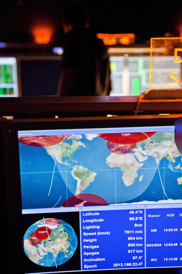
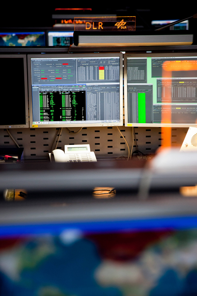
Leading nations in radar remote sensing are Germany, USA, Canada, Italy and Japan. Germany’s first radar satellite TerraSAR-X was launched in 2007 and is the world’s most modern system today. TerraSAR-X provides high-precision radar images with a resolution of 1 metre for scientific investigators and, in the meantime, a well-established commercial market. In addition, the data are also utilised for statutory tasks, such as environmental monitoring, regional planning, disaster prevention and security. However, the data acquisition of conventional radar satellites is limited to a two-dimensional imaging and only selected and very small areas can be monitored with a high resolution.
Innovation for Today: The Earth in 3-D
The team at the German Aerospace Center (DLR) in Oberpfaffenhofen, comprising Prof. Alberto Moreira, Dr. Gerhard Krieger and Dr. Manfred Zink, has pioneered this field, and has proposed and designed a new satellite mission, as well as managed its implementation in DLR Oberpfaffenhofen. TanDEM-X is a revolutionary remote sensing system, where the radar sensor is implemented on two satellites. Thanks to this innovation, precise information on the topography and vertical structure of the Earth’s surface can be derived. The goal of TanDEM-X is the generation of a global elevation model of unsurpassed quality and resolution. Using patented methods and technologies it is possible to derive a unique topographic model of the Earth’s surface, which is at least thirty times more accurate than the currently available global three-dimensional data sets. Moreover, the elevation model is universally homogeneous and the production costs are uniquely low.
Huge technical challenges had to be overcome before TanDEM-X could be launched in 2010. One example is the flying two satellites in close formation. Because, due to the Kepler laws, the satellite orbits can't be chosen at will, a special orbit concept was developed and patented, which optimises the spacing between the satellites and ensures safe formation flying without risk of collision. The trick was to combine the imaging geometry, orbital plane and orbit eccentricity in such a way that an optimum distance between the satellites is obtained. This patent is utilised in the TanDEM-X mission for the world’s first formation flight of two radar satellites. The distance between the satellites ranges from 150 to 500 metres, depending on the mission phase.
Other great challenges were the world’s first common operation of two cooperating satellites, the measurement of the satellite spacing down to a few millimetres, the optimum recording and processing of 1.5 petabyte (ca. 200 000 DVD) of data, and the mutual calibration and synchronisation of the instruments, whereby a relative accuracy of less than a picosecond is required. Prof. Moreira, Dr. Krieger and Dr. Zink were convinced from the beginning that these challenges could be mastered, although American radar experts expressed doubts on the feasibility and repeatedly commented that such an innovative mission proposal would only have had minimal chances to obtain NASA approval for realisation.
Since the successful launch of TanDEM-X in June 2010 the results exceed all expectations. The global elevation model is due to be available in 2014 for scientific and commercial applications, as well as for statutory tasks. TanDEM-X is financed and realised in a public-private partnership (PPP) between DLR and Astrium GmbH. The commercial potential of the TanDEM-X data set is extremely promising and is estimated to be in the range of hundreds of millions of euros today. In the last years more than 200 people have been employed at Astrium GEO-Information Services for the commercial exploitation of the data from the TerraSAR-X satellite. This number is expected to grow strongly with the various applications of the precise 3-D data and the worldwide increasing need for geoinformation products.
Innovation for Tomorrow: The Earth in 4-D
With TanDEM-X a new era of radar remote sensing began. In spite of many innovations, TanDEM-X has one significant limitation: it takes a year to completely image the Earth’s land surface once. Whereas this is fully acceptable for the generation of the digital elevation model, changes on the Earth cannot be observed adequately. Particularly the systematic monitoring of dynamic processes opens up a huge potential for the tomorrow’s knowledge society.
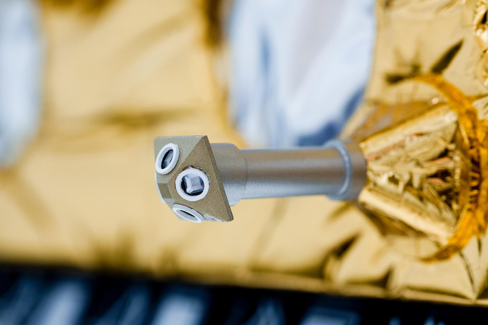
As a further innovation, even before the launch of TanDEM-X, the DLR team at Oberpfaffenhofen had developed and patented the technology of the digital radar antenna – a new, revolutionary imaging technique for future satellite systems. The key to the performance increase lies in the division of the radar antenna into small apertures, each connected to its own digital receive chain. By suitably combining the digital receive signals using high performance signal processors, several antenna beams can thus be formed simultaneously, enabling a much larger area to be imaged. A particularly promising further development of this technology makes use of a reflector, which deflects the radar pulses and greatly increases the effective area of the antenna. Foldable reflector antennas with a diameter of 15 m and more are already in use on communication satellites. By combining the digital radar antenna with a reflector, it is possible to increase the imaging performance by two orders of magnitude compared with TanDEM-X and to image the whole Earth twice per week with a single satellite.
Based on this revolutionary imaging technique, the mission proposal Tandem-L was developed as a follow-on to TanDEM-X. Tandem-L will monitor the Earth surface and its dynamics at high resolution with an unprecedented accuracy using a pair of extremely powerful radar satellites to provide urgently needed information for climate and environmental protection, as well as for a multitude of other applications. A decision on the realisation of this highly innovative radar mission is expected soon. With the future technologies developed in Oberpfaffenhofen, i.e. the coordinated operation of two radar satellites in close formation and the digital radar antenna, the door is open for a global remote sensing system for continuous observation of the Earth’s surface, such as exists today for weather forecasting using a network of geostationary satellites. In this way, time is enabled as fourth dimension beyond the third spatial dimension. The constant availability of up-to-date geo-information, which can be called upon quickly, precisely, globally and continuously, will allow a host of new commercial and scientific applications. For instance, crisis information systems based on such data will provide up-to-date information in real time on the crisis status for flooding, earthquakes, volcanic eruptions or during the development of a tsunami. Other important application examples come from the areas climate modelling, environmental monitoring and the conservation of natural resources. In this way, radar systems in space will become future pillars of the information system for the Earth and its environment.
Market Potential
Estimates of the world-wide sale of geo-data predict a four-fold increase in the turnover in the next ten years. However, we are only at the beginning of the market development for geo-information products based on satellite radar data. The global turnover from the sale of geo-data is approximately a billion euros per year. Assuming the current yearly increase of 15 % per year, it can be assumed that the market will exceed the four billion euro mark in ten years’ time. Considering that radar data now only have the relatively small market share of 17 %, the colossal innovations in the radar field make an over-proportional market growth seem likely. With the unrivalled products from the TanDEM-X mission and further visionary developments, Germany will extend its international lead in radar technology, and is predestined to secure a significant market share, hence creating sustainable jobs in this highly-innovative field.
Profile of the German Aerospace Center
DLR is Germany's national research centre for aeronautics and space. Its extensive research and development work in aeronautics, space, transportation, energy, defence and security research is integrated into national and international cooperative ventures. As Germany's Space Agency, the German federal government has given DLR responsibility for the forward planning and implementation of the German space programme as well as international representation of Germany's interests. DLR's research portfolio ranges from fundamental research to innovative development of the applications and products of tomorrow. In this way, DLR contributes the scientific and technical know-how that it has gained, thus enhancing Germany's industrial and technological reputation. DLR operates large-scale research facilities for the centre's own projects and as a service provider for clients and partners. It also promotes the next generation of scientists, provides advisory services to the German government and is a driving force in the regions centred on its various locations. Approximately 7000 people work for DLR; the centre has 32 institutes and facilities at 16 locations in Germany.
The Microwaves and Radar Institute is a research establishment of the DLR located at the Oberpfaffenhofen site near Munich. The main research field is space-based remote sensing with imaging radar sensors. The expertise of the 150 employees ranges from the design and development of new satellite missions, via the operation of airborne and space-borne radar systems to the processing and application of the resulting data. The Institute has an internationally recognised leading position in radar remote sensing and is decisively involved in the planning and implementation of national and international space programmes and projects.
The right to nominate outstanding achievements for the Deutscher Zukunftspreis is incumbent upon leading German institutions in science and industry as well as foundations.
The project “Radar Eyes in the Sky – revolutionary Technology for the Earth and the Environment” was nominated by the Helmholtz Association.
